Frequently Asked Questions
Yes, launching a weather balloon is completely safe, but only if you’re taking the necessary precautions. We never launch a weather balloon in an area with congested air space and all our flights include an on-board radar reflector which commercial airlines and air traffic controllers can detect and avoid via a radar operating in the 200 MHz to 2700 MHz frequency range. Additionally, we coordinate with the Federal Aviation Administration (FAA) which includes filing a HiBal Prelaunch NOTAM (Notice to Airmen). This important process informs air traffic controllers and pilots ahead of time to be on the lookout for a weather balloon if their intended flight path may be in the same airspace as our weather balloon. It also gives them a way of contacting us if they need to delay our launch or get an update on our weather balloon’s position. Every week there are over 10,000 weather balloons that are launched by meteorological organizations around the world. There are also an additional 20-40 amateur launches performed every week. That’s over 500,000 balloons being launched around the world every year. To date there has never been a report of an airplane striking a weather balloon. You can read full details about safety and regulations in the United States on our safety and regulations page.
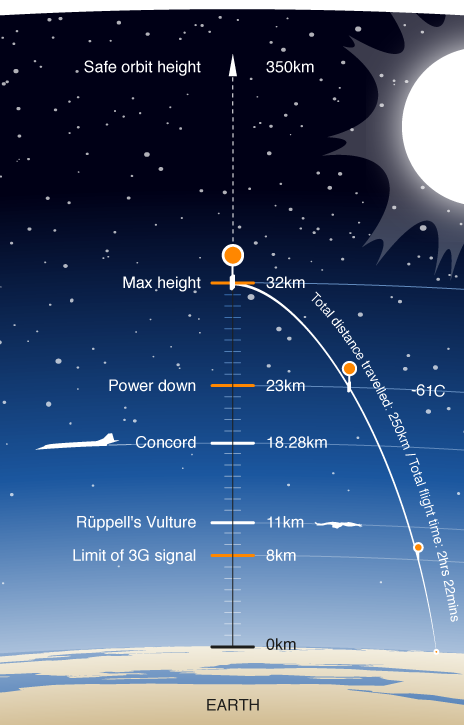
Flights typically last two to three hours. Flight time depends on how much helium we put in our balloon and the size of our parachute. The more helium we use, the faster our balloon will climb. It also means, though, that our balloon will burst at a lower altitude. Typical ascent times are one to two hours. A larger parachute will also increase our flight time by reducing the balloon’s descent rate. Typical descent times are 30 minutes to one hour. The values are calculated well ahead of launch time so we have a pretty good idea of exactly how long the balloon will be in the air.
The biggest factor on how far the payload will travel is the jet stream. There are four of them that constantly circle our globe from West to East at an altitude of roughly 60,000 ft. Jet streams can typically reach speeds of over 75 mph and can frequently be upwards of 150 mph. If one of these jet streams happens to be directly over our launch site, the payload could travel up to 150 miles! If the jet stream isn’t above our launch site, then the payload could land as little as 5 miles from the launch site.
Starting 7 days prior to our launch we look up the weather forecast on ground winds and the jet stream on using multiple weather and flight prediction websites. We’ve found that using a combined effort from multiple sources has led to very accurate results that are reliable +/- just a few miles. If our payload is predicted to land near a lake, mountain, populated area, etc. we will typically reschedule the launch or just move the launch site somewhere to accommodate a different landing zone.
Our flights include 3 separate positioning systems to help us locate the payload. Primarily, we use multiple forms of radio communications, which require an amateur radio license to operate. The radio communications provide us constant positioning reports throughout the flight via a ground based receiver. This communication method operates at all altitudes even over 60,000 ft. We typically have anywhere from 2 to 4 of these radio based trackers on board for redundancy. We do not recommend using a cellular-based GPS device. Not only are these unreliable at high altitudes, but special programming and consideration is needed to maintain compliance with FAR 22.925.
We have several specific vendors in our area, but typically any welding supply store will carry bulk helium, or a large national gas vendor. As of 2024, though, helium prices are getting very expensive!!
Payloads occasionally land in trees. We’ve been relatively fortunate on some of our flights that we’ve landed in trees. Many dangle by their parachute so that the payload is only 20 feet from the ground and we’re able to easily pull them down with a long extension pole. Tall trees becomes a bit trickier. Our recovery team carries a ladder during recovery operations, which we can use along with our extension poles. Beginning with OLHZN-17, we started adding a remotely controlled nichrome cutdown system to our payloads. This system allows us to cut the payload away from the payload string remotely from the ground. Beyond all that, we’ll keep trying to knock it down first, but the next safest thing to do in this situation is to have a certified tree climber retrieve our payload by climbing or using bucket trucks, etc. Sometimes the local fire department is interested to help retrieve our payload if they are able to get a truck close enough without getting stuck.
Unfortunately, in our fifth flight, OLHZN-5, we did experience an unfortunate and hazardous landing on a set of high voltage 155kV power transmission lines. Power lines are incredibly dangerous, especially high voltage lines. When it comes to power lines, we don’t mess around. In the rare event of a power line landing, we immediately notify the power company and the local fire department. Usually, the power company is very accommodating and will come release the payload from the lines and get it back to you without too much trouble. When it comes to power lines – NEVER attempt to retrieve the payload on your own, even if it’s low enough to reach, cut or dislodge. You should leave this to trained professionals!
Our Action Cameras we use typically have a 170° ultra wide angle lens, which is commonly refereed to as a fisheye lens. They provide a wider field of view, but distort the true nature of the image, specifically the shape of the horizon as the horizon approaches the extreme edges of the frame. The use of fisheye lenses are controversial particularly with followers that believe that the Earth is flat. So why do we use these lenses? There are a few reasons that we stick with what we have:
- The fisheye lens doesn’t bother us.
- The action cameras provide perfect compatibility with our computerized systems for controlling on/off cycles, battery life, fault tolerance, fault recovery and reliability.
- The action cameras are very lightweight which allows us to place up to 4 cameras onboard each flight.
- Some action cameras can be very inexpensive which means we can afford to lose or destroy them every once in a while if things go wrong.
- We can use fisheye correction software tools in post-production if we really want to correct the imagery.
- Our goal is not to prove the Earth is round (or flat). It’s not our focus.
- You can’t see much curvature at 35,000 m in altitude. You can see some, but many mistake the minimal curvature for flatness. A high altitude balloon only reaches about 30,000 meters in altitude. This is only about 8% of the altitude that the International Space Station is at. You can see an actual representation of expected curvature by altitude using this curvature simulator.
.
This is a to-scale depiction of what the curvature should actually look like at 34,291 m (our max altitude):
Earth Curvature at 34,291 m
We understand that many dislike the fisheye camera lens, but we don’t intend to change our camera selection anytime soon. If you dislike it, we highly recommend designing your own flight with your own camera. We even have a how-to guide that shows what you need to know. It’s a great project, so give it a try! We’re here to have fun and get kids interested in science and technology. We hope you’ll have fun with us even with the fisheye lenses.
All of the weather balloons that we use at Overlook Horizon are 100% biodegradable natural latex. Unlike metallic nylon or neoprene (party) balloons, our balloons completely biodegrade within 24-36 months in all conditions. Within 24 months, our balloons are completely homogenous with soil. Our balloons are not made with any preservatives, harmful chemicals, petroleum, neoprene, plastic or metal, drastically reducing their footprint on the land and sea.
Additionally, our balloons are manufactured with such precision that a proper burst will always result in a balloon shattering. The hundreds of tiny latex pieces will fall back to Earth and begin degrading instantly, enhanced by the additional surface area of hundreds of small pieces. Unlike party balloons which may tear along a seam and come back down to land whole, our balloons will always be completely unrecognizable once their fragments return to the ground.
We take our impact on the environment seriously, and although our balloons do take a little time to completely biodegrade, they are hundreds to thousands times faster than any other high altitude balloons. The manufacturer of the balloons that we use is proud that over the course of 40 years of soundings, their balloons have always experienced a revolving-door 24-36 month biodegradation period, and a negligible long term effect on the environment.
Weather balloons are launched twice daily by the National Weather Service with a radiosonde payload to measure the atmospheric conditions. The radiosonde can be collected and recycled. All NWS radiosondes include return shipping instructions.